


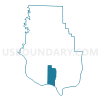
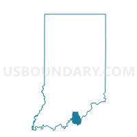
BOONE WEST, Harrison County, Indiana
About
Outline

Summary
| Unique Area Identifier | 577633 |
| Name | BOONE WEST |
| County | Harrison County |
| State | Indiana |
| Area (square miles) | 17.95 |
| Land Area (square miles) | 17.85 |
| Water Area (square miles) | 0.09 |
| % of Land Area | 99.48 |
| % of Water Area | 0.52 |
| Latitude of the Internal Point | 38.05438110 |
| Longtitude of the Internal Point | -86.10627020 |
Maps

Graphs
Select a template below for downloading or customizing gragh for BOONE WEST, Harrison County, Indiana


Neighbors
Neighoring Voting District (by Name) Neighboring Voting District on the Map
- BOONE EAST, Harrison County, IN
- HARRISON SOUTHEAST, Harrison County, IN
- HETH EAST, Harrison County, IN
- WEBSTER WEST, Harrison County, IN
Top 10 Neighboring County Subdivision (by Population) Neighboring County Subdivision on the Map
- Brandenburg CCD, Meade County, KY (12,805)
- Harrison township, Harrison County, IN (12,484)
- Webster township, Harrison County, IN (1,781)
- Boone township, Harrison County, IN (1,391)
- Heth township, Harrison County, IN (1,278)
Top 10 Neighboring Place (by Population) Neighboring Place on the Map
Top 10 Neighboring Unified School District (by Population) Neighboring Unified School District on the Map
Top 10 Neighboring State Legislative District Lower Chamber (by Population) Neighboring State Legislative District Lower Chamber on the Map
Top 10 Neighboring State Legislative District Upper Chamber (by Population) Neighboring State Legislative District Upper Chamber on the Map
Top 10 Neighboring 111th Congressional District (by Population) Neighboring 111th Congressional District on the Map
Top 10 Neighboring Census Tract (by Population) Neighboring Census Tract on the Map
- Census Tract 9704.02, Meade County, KY (7,559)
- Census Tract 604, Harrison County, IN (7,489)
- Census Tract 606, Harrison County, IN (6,881)
- Census Tract 605, Harrison County, IN (5,885)